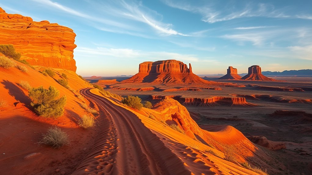
Page, Arizona gives you big canyon views, tight slot corridors, and desert trails that can turn risky fast. Heat, flash floods, soft sand, and exposed ledges shape almost every hike here. Use this guide to match each route with your time, comfort level, and plan for water, weather, permits, and safe footing.
What’s in This Article
- Antelope Canyon Slot Hike
- Horseshoe Bend Overlook Trail
- Upper and Lower Antelope Canyon Walks
- Hanging Garden Trail at Glen Canyon Dam
- Wahweap Hoodoos Loop
- Lake Powell Rim Walk (Page to Lone Rock)
- Wire Pass and Buckskin Gulch Access
- Toadstools Trail in Grand Staircase-Escalante
- Navajo Mountain Viewpoint Trail
- Rainbow Bridge Approaches and Shoreline Hikes
- How to Plan Safe Hikes Near Page, Arizona
- Frequently Asked Questions
Quick Answer
The best hikes near Page, Arizona include Antelope Canyon, Horseshoe Bend, Hanging Garden Trail, Wire Pass, the Toadstools, and shoreline routes near Lake Powell. Choose guided slot canyon tours for iconic photos, short overlooks for easy views, and longer desert routes only when you have strong navigation, water, and weather plans.
Key Takeaways
- Book Antelope Canyon tours ahead of time because you need an authorized guide for access.
- Check flash-flood forecasts before any slot canyon hike, even when the sky looks clear.
- Start exposed desert hikes near sunrise or late afternoon to avoid the worst heat.
- Carry more water than you think you’ll need, plus sun protection and sturdy shoes.
- Match each route to your comfort with ledges, ladders, soft sand, and remote terrain.
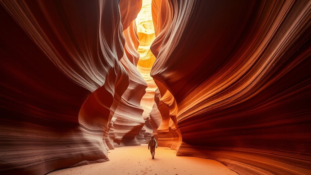
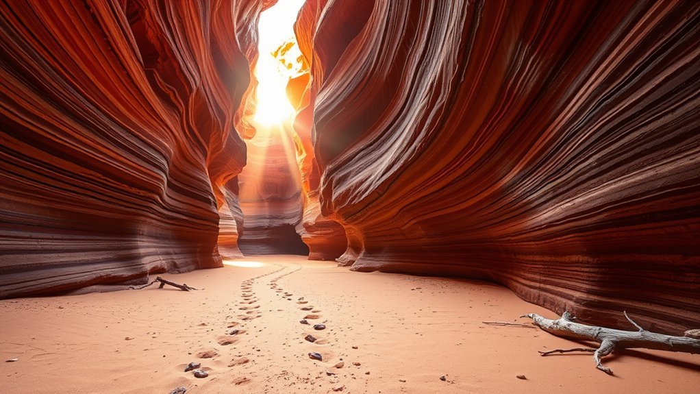
Antelope Canyon Slot Hike

Step into Antelope Canyon and you’ll feel the desert close around you in the best way. Narrow sandstone walls glow with orange, red, and gold as light filters down from above. You’ll follow a winding slot carved by flash floods, moving single file through smooth rock that shifts in color with each turn.
You must join an authorized guided tour, which helps protect the canyon and keeps you aware of weather risk. Guides explain safety, geology, and Navajo cultural context as you walk. You’ll learn how water, sand, and time shaped the canyon’s striations and curves.
Photography takes patience because light changes fast in the narrow space. Use a steady hand, keep your camera secure, and avoid blocking the group for long shots. Wear sturdy shoes and light layers because sunlit areas can feel warm while inner corridors stay cool.
Warning: Do not enter slot canyons during flash-flood watches, warnings, or unstable weather near the drainage area.
Horseshoe Bend Overlook Trail
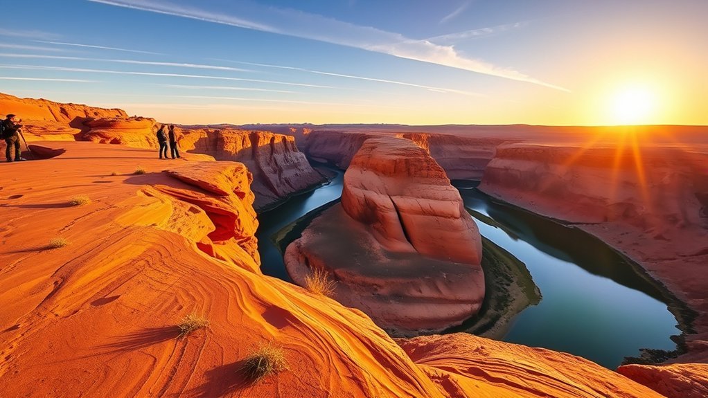
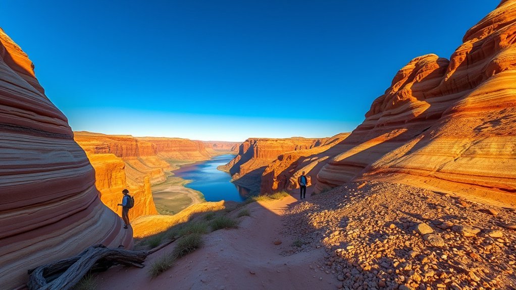
The Horseshoe Bend Overlook Trail gives you one of the most famous views near Page with a short walk from the parking area. You follow a sandy path to a red-rock rim above the Colorado River. Below you, the river carves a wide horseshoe curve through the canyon.
Most visitors can handle the trail, but the open desert setting still demands care. Bring water, sun protection, and shoes that grip sand and slickrock. Arrive early or late for cooler air, softer light, and fewer people along the rim.
Stay alert near the edge because the drop is steep and exposed. Use signed viewing areas when available, and keep children close. A wide-angle lens helps you capture the full meander without stepping too close to the rim.
Upper and Lower Antelope Canyon Walks
Upper and Lower Antelope Canyon both place you inside a surreal, light-filled world of sculpted sandstone. You move with a guide through corridors shaped by flash floods, where curves shift from pale gold to deep orange. Each canyon offers a different pace and feel.
Upper Antelope Canyon tends to feel roomier and draws visitors who want classic light shafts. Lower Antelope Canyon has more stairs, ladders, and tight squeezes, so it suits visitors who feel steady on their feet. Both routes require respect for the fragile rock and quick-changing weather.
- Plan ahead: Book tours early, choose the light you want, and check tour rules before arrival.
- Move carefully: Follow your guide, watch uneven floors, and give other visitors space.
- Respect the canyon: Stay on the route, avoid touching walls, and leave no trash behind.
Hanging Garden Trail at Glen Canyon Dam
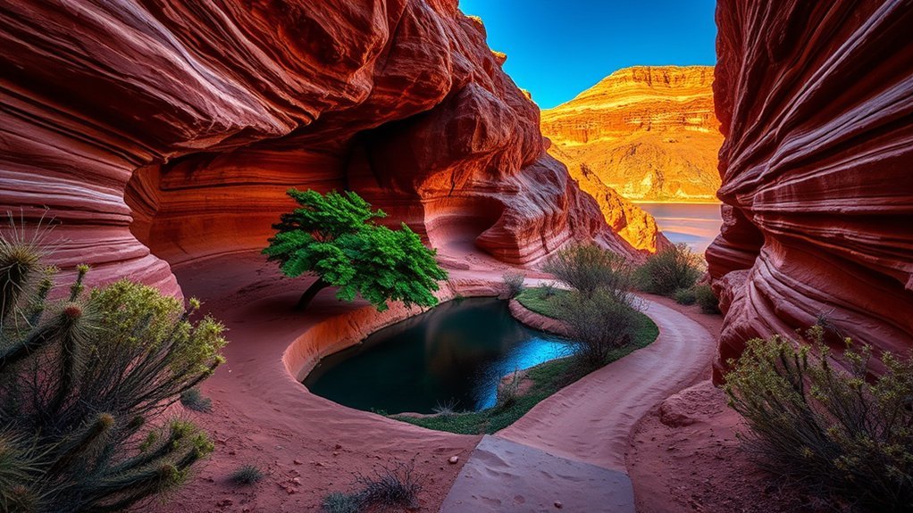
The Hanging Garden Trail gives you a quiet patch of green in the high desert near Glen Canyon Dam. Seep springs feed ferns and other plants that cling to moist rock. The shade and damp air can feel surprising after the open sandstone nearby.
You follow a short, easy path with sandy and rocky footing. Bring water, a camera, and shoes with grip because some stone can feel slick. Birds often move through the greenery, and the trail rewards slow observation more than speed.
This route works well when you want a brief walk between longer outings. You can spend a short visit at the garden or linger to study moss, ferns, and the contrast between wet rock and dry cliffs.
| Feature | Distance | Vibe |
|---|---|---|
| Trail length | 0.5 mile | Serene |
| Elevation | Minimal | Cool shade |
| Highlights | Ferns, seep springs | Intimate wildness |
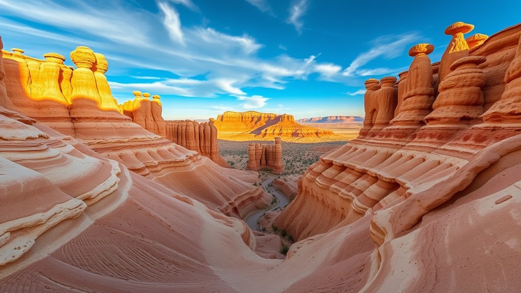
Wahweap Hoodoos Loop
Wahweap Hoodoos brings you into a strange landscape of pale sandstone towers and sculpted fins. The formations glow during golden hour, and the changing light gives you fresh photo angles at nearly every turn. The area can feel remote, so plan with care before you leave the car.
Trailhead and Parking
Start by confirming the correct trailhead and current road conditions before you drive out. Some access roads in this region can become rough, sandy, or muddy after storms. A small parking area may fill quickly during cooler parts of the day.
- Arrive early or late in the day to avoid the strongest heat.
- Use a vehicle suited to current road conditions, especially after rain.
- Park only where allowed so emergency vehicles and other visitors can pass.
Hoodoos and Formations
The landscape opens into a maze of slender hoodoos, ledges, and sculpted stone. Cream, pink, and rust colors shift as shadows move across the pillars. Slow down so you can notice cross-bedding, ripple marks, and small alcoves carved by erosion.
Stay on durable surfaces when you can and avoid fragile crusts or loose slopes. The hoodoos look sturdy, but wind and water keep shaping them. Give each formation space so future visitors can enjoy the same textures and views.
Safety and Timing
The desert sun can turn a pleasant walk into a hard outing quickly. Plan around cooler hours, and avoid midday heat when the route feels exposed. Check weather, road reports, and local notices before you go.
- Start early: Beat the heat, catch long shadows, and limit sun exposure.
- Hydrate often: Carry enough water, salty snacks, and electrolytes for hot days.
Carry sun protection, a map, and a charged phone. Tell someone your route and expected return time before you leave.
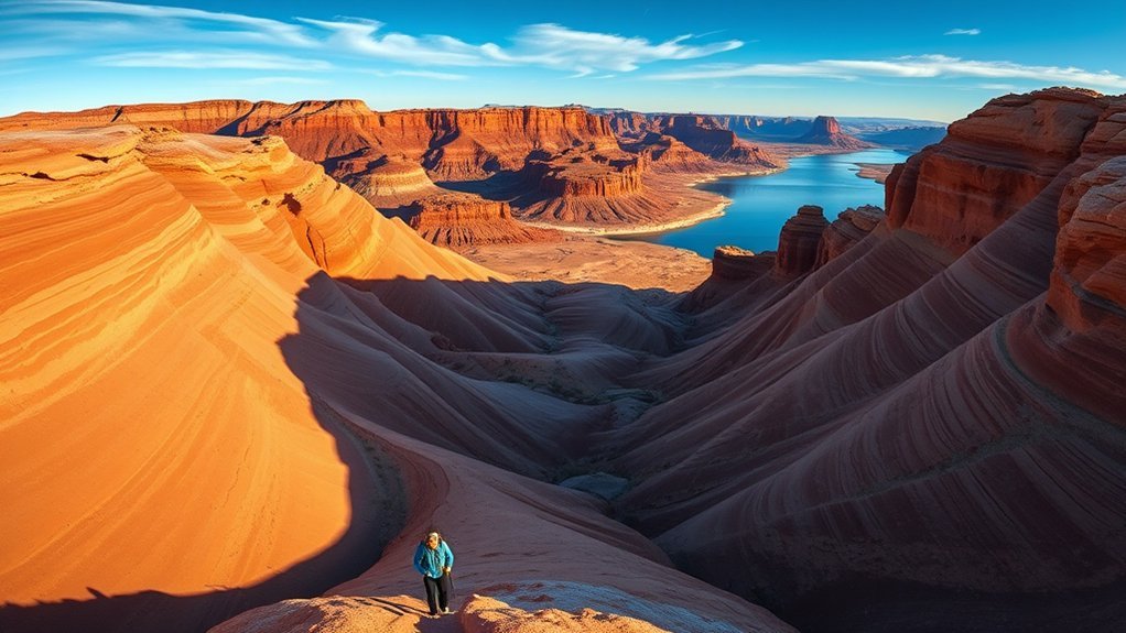
Lake Powell Rim Walk (Page to Lone Rock)
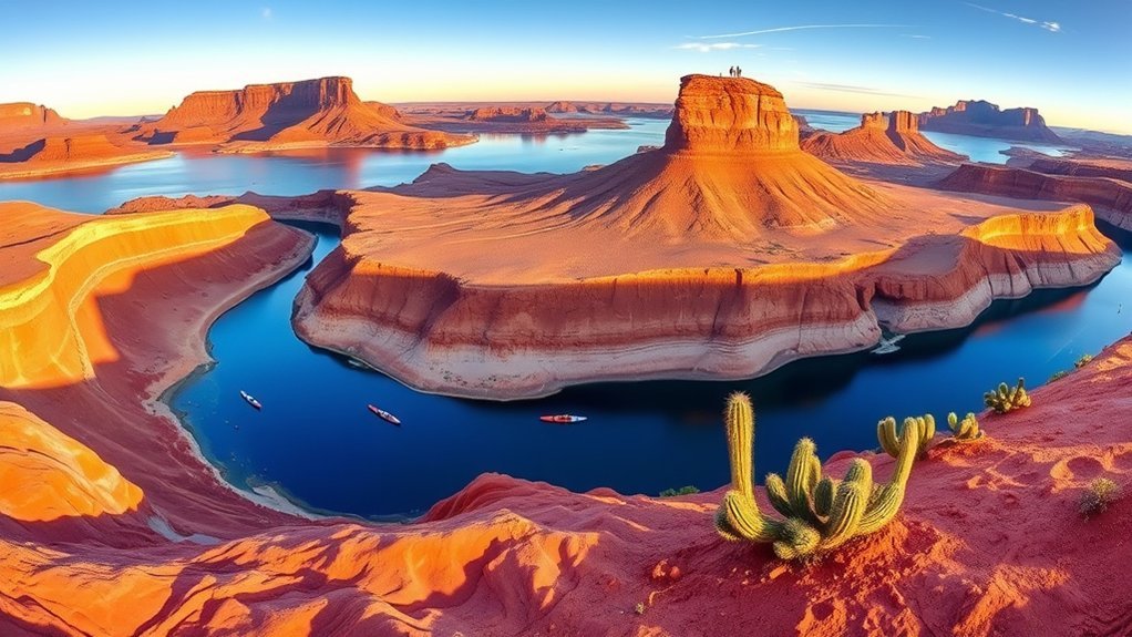
The Lake Powell Rim Walk frames Page against blue water, red cliffs, and wide desert sky. You move along sculpted sandstone ledges with open views of inlets, coves, and Lone Rock in the distance. The route can feel flexible, so choose an out-and-back distance that fits your time and energy.
Parts of the rim may feel informal or lightly marked. Bring a map or GPS, and don’t rely on cell service. Watch your footing on wind-polished rock, sand, and exposed edges.
Early morning or late afternoon gives you the best mix of light and comfort. Colors deepen, shadows define the cliffs, and the lake breeze can cool the route. Carry water, sun protection, and sturdy shoes even for a short walk.
Wire Pass and Buckskin Gulch Access
Wire Pass gives you a popular route into the Buckskin Gulch area, one of the most serious slot canyon environments near Page. You start from a remote trailhead and enter terrain where heat, navigation, and flash floods matter. Check permits, road conditions, and forecasts before you commit.
Trailhead Location Details
The Wire Pass trailhead sits off House Rock Valley Road, which can change quickly with weather. Dry conditions can mean dust and washboards, while storms can create mud and difficult driving. Confirm access before you leave Page or Kanab.
From the lot, worn paths lead toward the wash and the slot canyon approach. Note landmarks on your way in so you can return with confidence. Carry a map or downloaded route because remote canyons don’t always offer dependable signal.
- Trailhead basics: Expect a simple desert access point with limited services.
- Starting terrain: Plan for sandy wash, rock ledges, and uneven footing.
- Navigation cues: Watch sandstone fins, cairns, and wash junctions carefully.
Permit & Timing
Check current permit rules before you enter Wire Pass or Buckskin Gulch. Day use and overnight rules can differ, and managers may change access after storms or high water. Carry proof of any required permit with you on the hike.
Start early enough to avoid heat and give yourself a safe exit window. A dry wash can turn dangerous when storms hit the drainage miles away. If the forecast looks unstable, choose another hike.
Safety & Gear Tips
Narrow canyons can shift from calm to dangerous in minutes. Check weather often, read current conditions, and tell someone your exit time. Pack layers, sturdy shoes, and a lightweight pack that won’t snag canyon walls.
- Carry 2 to 3 liters of water, electrolytes, a headlamp, a map, and first-aid supplies.
- Bring an emergency shelter, whistle, and backup navigation for low-signal areas.
- Use trekking poles for sand and slickrock if they help your balance.
Respect signs and closures. Turn back before risk rises, not after you feel trapped.
Toadstools Trail in Grand Staircase-Escalante
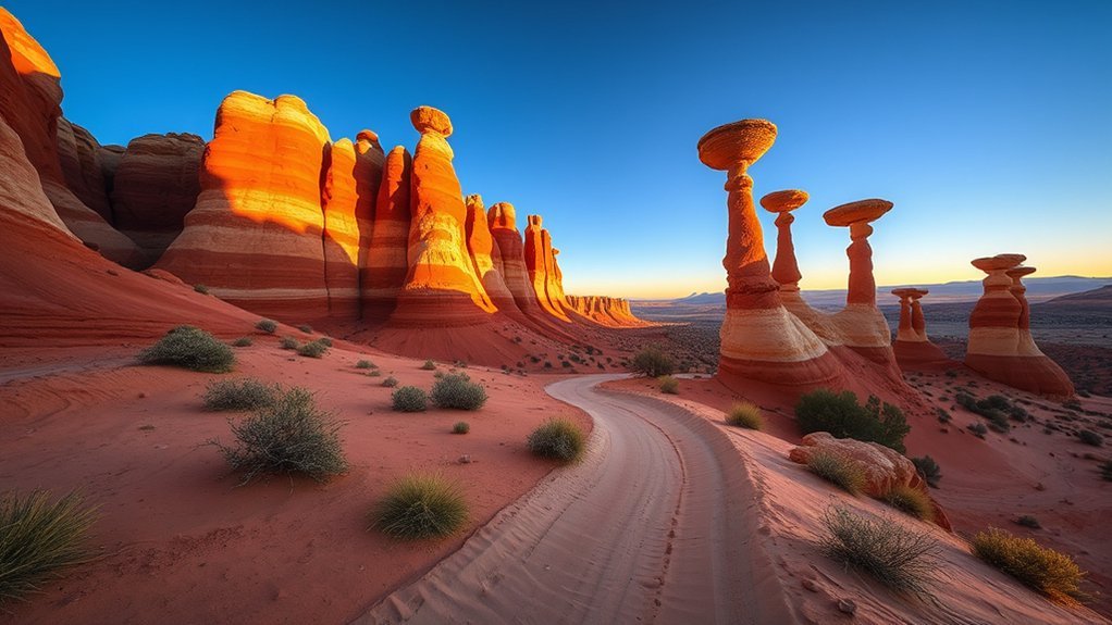
The Toadstools Trail in Grand Staircase-Escalante feels like a short walk through a natural sculpture garden. Wind and water have shaped stone mushrooms, balanced caps, and delicate hoodoos from layered rock. The route offers a compact taste of the region’s strange badlands.
You follow sandy soil and slickrock, so wear sturdy shoes with good traction. Morning and late afternoon bring softer light and cooler air. The trail is family-friendly for many visitors, but the exposure still calls for water, hats, and sunscreen.
Stay on the route and avoid climbing on fragile formations. Pack out trash, give other hikers room for photos, and let the quiet landscape set the pace.
Navajo Mountain Viewpoint Trail
The Navajo Mountain Viewpoint Trail rewards you quickly with sweeping views of Navajo Mountain. The route can feel short, rocky, and exposed. Bring sturdy shoes, sun protection, and enough water for the heat.
Navajo Mountain Views
Navajo Mountain rises like a lone fortress on the horizon. From red sandstone ledges, you’ll see buttes, mesas, and long desert lines under a wide sky. Light changes fast, so the view can feel different each time you look up.
- Sunrise: Cooler air and soft gold light make photos easier.
- Midday: Strong contrast helps you see ridges and geologic layers.
- Sunset: Long shadows and red tones create a bold silhouette.
Move slowly near ledges, and treat the viewpoint as part of Navajo Country. Respect signs, closures, and local guidance.
Trail Difficulty & Tips
The trail may be short, but uneven sandstone surfaces and loose gravel demand steady footing. Pace yourself if the route gains elevation quickly. Use trekking poles if balance concerns you.
Shade can be scarce, and glare off pale rock can feel intense. Carry water even for a brief walk. Stay on the route to protect fragile desert soil.
Rainbow Bridge Approaches and Shoreline Hikes
From Page, Rainbow Bridge trips can combine lake travel, shoreline walking, and views of a huge natural arch. Approaches vary with access, water levels, weather, and route choice. Plan ahead so you don’t treat this as a casual last-minute hike.
You can choose a shoreline stroll from nearby coves when conditions allow, or plan a boat-and-hike trip that fills much of the day. Watch for slickrock, sand, wind, and changing lake conditions. Bring water, sun protection, sturdy shoes, and patience.
Set out from Page to discover Rainbow Bridge through shoreline walks or boat-and-hike routes with red cliffs, blue water, and shifting light.
- Boat access: Choose this for scenic travel and less hiking when conditions allow.
- Shoreline hikes: Pick these for solitude, photos, and flexible distance.
- Multi-segment trips: Combine paddling, boating, and hiking only with a sound plan.
How to Plan Safe Hikes Near Page, Arizona
Smart planning matters as much as trail choice near Page. Many routes cross exposed desert, remote roads, or narrow canyons with little shade. Build your plan around water, weather, permits, and an honest view of your group’s limits.
- Check weather for the full drainage area, not just the trailhead.
- Confirm permits, guided-tour rules, parking rules, and road conditions before departure.
- Carry water, snacks, sun protection, navigation, and a basic first-aid kit.
- Tell someone your route, start time, and planned return time.
- Choose a shorter hike when heat, storms, or road conditions raise risk.
Pro tip: Plan one major hike per day, then use short overlooks or shaded walks as flexible add-ons.
Frequently Asked Questions
Are permits required for backcountry camping near Page?
Yes, you may need permits for many backcountry campsites around Page, especially on managed recreation lands and Navajo Nation lands. Check the rules for your exact route before you go, and respect seasonal closures, quotas, and Leave No Trace practices.
What wildlife should hikers expect to see?
You may see mule deer, coyotes, jackrabbits, lizards, ravens, hawks, and other desert wildlife. Keep distance from all animals, never feed them, and watch where you place your hands and feet in rocky areas.
Are dogs allowed on these trails?
Some trails allow dogs, but many guided canyon tours, protected areas, and tribal lands restrict pets. Check each route before you bring a dog, and carry extra water, waste bags, and paw protection for hot rock and sand.
When is the best time of day to avoid crowds?
Early morning usually gives you the best chance at quieter trails, cooler air, and softer light. Late afternoon on weekdays can also work well, but leave enough daylight for your return.
What cellphone reception and emergency services are available?
Cell service can be spotty or unavailable on remote roads, canyon routes, and lake approaches. Carry offline maps, consider a satellite messenger for remote hikes, and don’t count on fast rescue access.
Conclusion
The best hikes near Page, Arizona reward you most when you pair bold scenery with careful planning. Choose guided slot canyons for sculpted sandstone, short overlooks for fast views, and remote routes only when weather and access line up. Pack water, sun protection, sturdy shoes, and a clear route plan before every hike. Start with the trail that matches your time and comfort, then let Page’s red rock country pull you toward the next view.