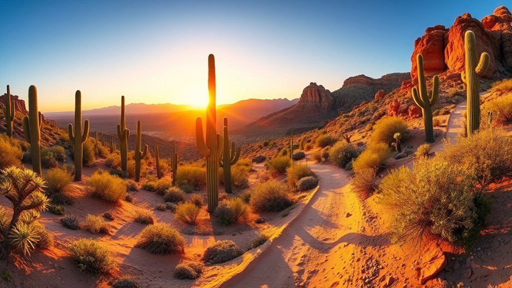
From Page, you can stitch together a day of stunning geology and easy walks that never feel rushed. Wander beams of light in Antelope and Upper Slot, time sunrise at Horseshoe Bend, or drive the Glen Canyon overlooks and shorelines. Take a boat to Rainbow Bridge, poke at fossils near the Vermilion Cliffs, or watch river traffic at Lees Ferry—each option rewards short hikes, great photos, and quiet moments that keep you planning the next stop.
Antelope Canyon and Upper Slot Canyon Photography Tour
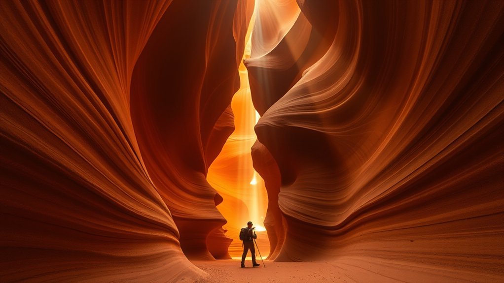
Sunlight threads through narrow sandstone corridors as you step into Antelope Canyon, and your camera becomes a companion mapping sculpted walls, drifting dust, and sudden bursts of color. You move deliberately, following a guide who times light beams and frames — you learn to wait for the shaft that will etch a face in ochre. The passage narrows, feels intimate; touch is discouraged, but your lens drinks in texture: ripples like frozen waves, thin striations, pockets where shadow pools. You’ll switch lenses often, balancing wide angles for sweeping curves and a longer glass for compressed abstracts. Breath shows as motes when the sun slants right; a slow exposure turns them into a ghostly veil. Beyond Antelope, an upper slot canyon offers quieter compositions — fewer crowds, more subtle palettes, and angles that reward patience. By day’s end you’ve collected not just images but a practiced eye for light, contour, and the canyon’s discreet gestures.
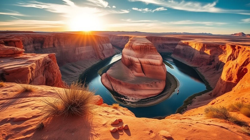
Horseshoe Bend at Sunrise or Sunset
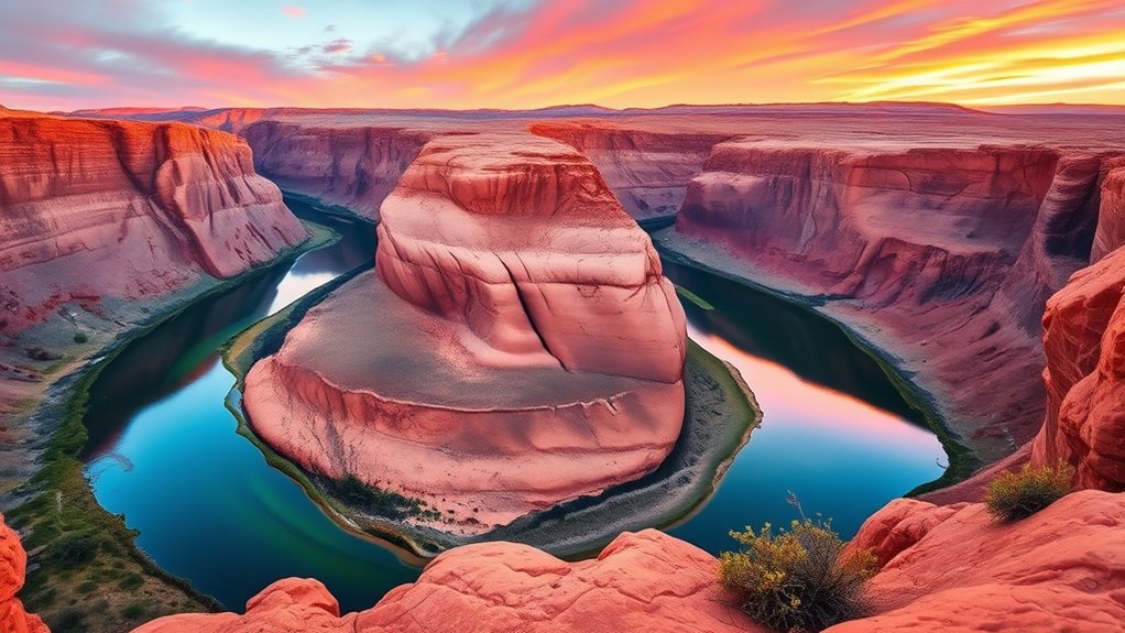
At dawn or as the sun slips low, you’ll find Horseshoe Bend unfolding like a painted amphitheater, the Colorado River carving a gleaming ribbon around the cliff’s lip. You step out onto the rim and the air feels thin and sharp; light pools on sandstone, shadows stretch into the bend, and for a moment the world narrows to that curve of water and stone.
At dawn or dusk Horseshoe Bend unfurls — a painted amphitheater where river and light carve quiet, sharp beauty
You move along the rail, camera ready, noticing color shifts and the hush of other visitors who keep their voices low. The view rewards patience — reflections, a quiet boat far below, the canyon’s textures catching gold or mauve.
- Arrive early or late to avoid midday glare
- Bring a wide-angle lens for the full sweep
- Wear sturdy shoes for the sandy trail
- Mind the edge; railings help but stay cautious
- Stay for changing light; each minute alters the scene
Glen Canyon Dam and Lake Powell Scenic Drive
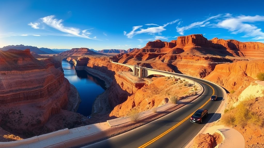
After taking in the sweep of Horseshoe Bend, drive a short way toward the dam and you’ll feel the scale change — sheer walls give way to the engineered hush of Glen Canyon Dam and the vast, glassy expanse of Lake Powell stretching behind it. You pull into the overlook and the concrete arc reads like a human answer to the canyon’s age-old geology; turbines whisper beneath your feet and the air carries a faint metallic cool. Walk the rim road and the shoreline unfolds in improbable coves and sandstone fingers, sunlight carving highlights and deepening blues on the water. You stop often — to trace striations in the rock, to watch a houseboat drift like a toy, to note the contrast between engineered geometry and wild erosion. As you drive the scenic loop, each turn frames a different composition: dam, lake, cliff, open sky. By the time you loop back toward Page, the landscape feels both tamed and stubbornly, beautifully ancient.
Rainbow Bridge National Monument Boat Excursion
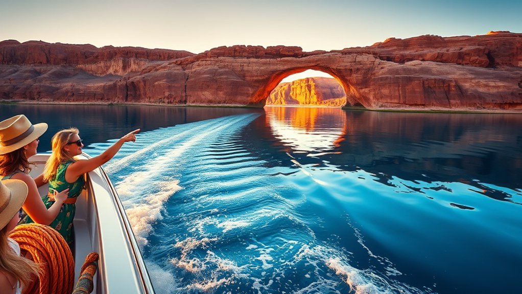
Following the wake of the boat, you’ll feel the canyon close in around you as Lake Powell narrows into a corridor of sculpted red walls, the sound of the motor mingling with distant drip and wind. You watch light crawl across banded sandstone, and the captain eases to a stop beneath the vast span. Stepping onto sun-warmed sand, you approach Rainbow Bridge—a monumental arc carved by time that hangs like a doorway to another era. You trace its scale with your eyes, noticing mineral streaks and tiny plant pockets clinging to ledges. The silence beneath the arch feels intentional, a hush that makes your footsteps and breath loud. You’ll want to linger, photograph angles where shadow sculpts the curve, and listen for bird calls echoing off cliff faces. Consider packing water, a hat, and respect—this is a sacred place for local tribes and a fragile wonder.
- boat timing and tides
- sun position for photos
- light, shadow, scale
- respectful behavior
- water and shade planning
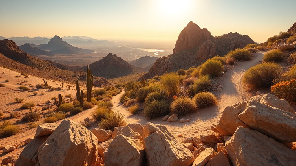
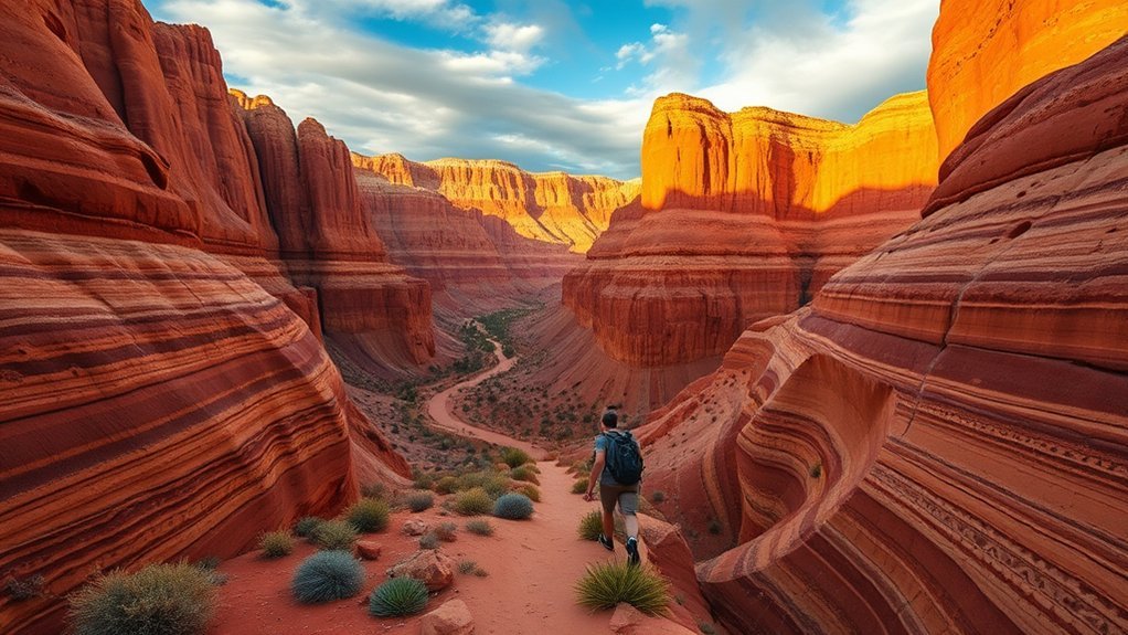
Vermilion Cliffs and Paria Canyon Day Hike
You’ll need the right permits and an early start to explore Vermilion Cliffs and the Paria—access is limited and the trails change with water and weather. Choose a route that matches your stamina, from a gentle walk along the Paria River to a longer canyon loop past sculpted sandstone. Prepare with plenty of water, navigation tools, and a plan for heat, flash floods, and remote conditions.
Permits and Access
Because the Vermilion Cliffs and Paria Canyon sit on fragile, limited-access public land, getting the right permits and timing can make or break your day hike. You’ll feel the weight of regulations as part of caring for this place: permit windows, seasonal closures, and quota drops shape when you can stroll into sandstone light. Check BLM and USFS sites, reserve early in high season, and leave room for road or weather delays. Carry printed confirmations and ID; rangers appreciate preparedness. Park thoughtfully where indicated and respect private land boundaries.
- Reserve permits well in advance
- Monitor seasonal closures and flash flood alerts
- Bring printed permit and ID
- Use designated parking and trailheads
- Be flexible with timing and backup plans
Hike Route Options
While the Vermilion Cliffs and Paria Canyon share the same red-rock drama, each route offers a distinct rhythm—choose a short out-and-back to savor sunlit fins and easy footing, or commit to a longer canyon splice that threads narrows, slickrock benches, and braided washes. You’ll notice how the short loops let you linger on sculpted ridges, study lichen-stippled walls, and return before heat builds. The longer option asks you to read the land: pick your line through potholes, skirt seasonal seeps, and time crossings where the sand funnels. As you hike, light shifts sculpt new textures; birds and distant watercourses punctuate silence. Both routes reward close attention—you’ll finish with a refined sense of place and a handful of memorable views.
Safety and Preparation
If you’re heading into the Vermilion Cliffs or Paria Canyon for a day hike, plan like the landscape expects you to pay attention: study route notes, check weather and flash-flood forecasts, and tell someone your turnaround time. You’ll move through sun-baked sandstone and narrow washes; keep senses tuned to sky, wind, and distant animal calls. Prepare small, smart: your pack should balance water, shade, and emergency gear without slowing your pace. Read cairns and washes like sentences, and adjust when the trail erases itself.
- Carry 3–4 liters, hat, and SPF-rated clothing.
- Bring a map, compass, and a charged GPS device.
- Wear sturdy shoes with ankle support.
- Pack a lightweight emergency bivy and whistle.
- Know exit points and conservative time margins.
Marble Canyon and Lees Ferry River Access
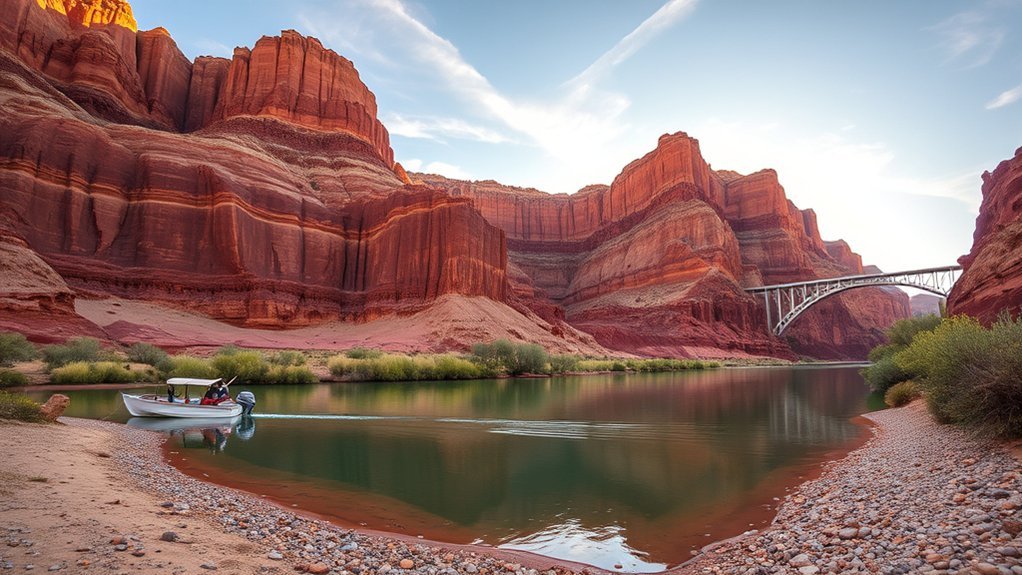
You’ll feel the scale of Marble Canyon the moment the sheer red walls swing into view, a tight throat of the Colorado River that’s both rugged and quietly majestic. Walk or drive down toward Lees Ferry and you’ll find the historic river access where anglers, rafters, and hikers launch into long stretches of braided current and quiet eddies. Take a moment to watch the water and the light on the cliffs — it teaches you the landscape’s pace and how to plan your next move.
Marble Canyon Overview
Nestled where the Vermilion Cliffs give way to the Colorado River, Marble Canyon feels like a hidden hinge between high desert and deep-water country, and you’ll notice right away how the light chisels reds and creams from the canyon walls. You can wander short trails, pause at overlooks, and hear the hush where geology meets river rhythm. The place feels intimate — a sequence of sculpted alcoves, slickrock benches, and sudden drops that frame distant mesas.
- Narrow canyon vistas that change with sun angle
- Exposed Navajo sandstone and fossil-rich ledges
- Quiet pullouts for sketching or photography
- Short, easy hikes with dramatic end views
- Birdlife and subtle desert flora on the slopes
Lees Ferry River Access
Step down from the rim and the river suddenly takes over the landscape — Lees Ferry is where the Colorado slows, widens, and becomes an unmistakable ribbon of green against red-rock cliffs. You’ll find a gravel boat ramp, shaded picnic spots, and a small parking area where anglers rig lines and guides check gear. Walk the short trail to the historic ferry site and imagine the first crossings as you scan the river’s calm pools and swift riffles. Launch here for float trips or hike upstream to quiet eddies where canyon walls press close. The light changes fast; morning casts silver on the water, late afternoon warms the stone. You leave the noise of the highway and enter a softer, river-shaped world.
Navajo Village Cultural Visit
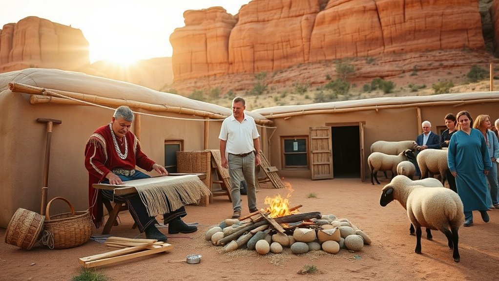
Curious what daily life looks like on Navajo land? You arrive at a small village where adobe homes and wind-sculpted mesas frame your view. Guides greet you with quiet confidence, inviting you to listen to stories that map history into place. You watch a weaver’s hands move, steady and practiced, while the smell of pinon smoke and fresh cornbread lingers. Every explanation is grounded in land, kinship, and seasonal rhythms, and you leave with a deeper sense of how culture and landscape interlock.
- Observe a weaving demonstration and learn pattern meanings
- Taste traditional foods and ask about seasonal ingredients
- Hear stories about creation, place names, and family ties
- Visit a hogan and learn about its construction and symbolism
- Support local artisans by purchasing handmade jewelry or rugs
You walk away respectful, changed by small, precise moments that reveal daily life rather than exoticize it.
Frequently Asked Questions
Are Pets Allowed on These Tours or Trails?
Yes — some trails and tours allow pets, but rules vary by site and operator. You’ll need a leash, cleanup supplies, and patience; certain sensitive areas, guided tours, or slot canyons often prohibit animals for safety and preservation.
What Cellphone Coverage Is Available at Each Destination?
Coverage varies: you’ll get decent cell service in towns and main viewpoints, but you’ll lose signal on remote trails, deep canyons, and some scenic overlooks — bring maps and offline tools, since connections can drop unexpectedly.
Are Restrooms and Drinking Water Available Along the Routes?
Yes — many trailheads lack facilities, so only about 30% of sites offer restrooms and drinkable water; you’ll carry water, scout vault toilets at major viewpoints, and savor quiet stretches where desert silence replaces running taps.
Do Any Sites Require Permits or Special Passes Beforehand?
Yes — some spots need permits or timed-entry passes, especially Antelope Canyon and Lake Powell boat launches; you’ll book online in advance, carry confirmations, and plan around limited slots so your day trip won’t be spoiled.
Are These Trips Wheelchair- or Stroller-Accessible?
Yes — some sites are accessible, but others aren’t: you’ll find paved overlooks and visitor centers easy to navigate, while narrow trails, stairs, or sand-drift areas block strollers or wheelchairs, so plan each stop carefully.
Conclusion
You’ll leave Page with a pocket full of moments—sunlight threading Antelope’s ribs, the horseshoe of the river like a bronze bracelet, the dam’s silhouette steady as a lighthouse. Let each view be a compass needle: pick a canyon, a boat, a rim and follow it. You’ll carry back more than photos—stone whispers, river breath, a sketchbook of small discoveries that’ll keep pulling you toward the red-rock horizon.