Most people don’t know Arizona’s trails can shift from red-rock hoodoos to alpine tundra in a single day. You’ll find hikes that test your legs and others that let you move slow and listen — each trail offers a different kind of reward. I’ll outline 15 top routes, from short, iconic climbs to multi-hour rim descents, so you can pick what fits your pace and season — and plan the right gear before you go.
Camelback Mountain — Echo Canyon Trail
If you’re up for a steep, heart-pounding climb, Echo Canyon Trail on Camelback Mountain delivers sweeping Phoenix skyline views and rugged desert scenery in just under two miles each way. You’ll move deliberately over rock steps and handholds, feeling solitude widen with every switchback. The Trail Difficulty is high — expect exposed sections, tight scrambles, and sustained elevation gain that demand focus and fitness. Bring water, sun protection, and a plan to start early; turning back is okay if conditions shift. Reach the summit and you’ll stand taller, liberated by wide desert light and the city spread below. The return tests endurance differently, rewarding steady breathing and a clear, fierce sense of accomplishment.
Bright Angel Trail, Grand Canyon National Park
When you step onto Bright Angel Trail, you’ll feel the canyon unfold with every switchback—sheer walls, sun‑washed ledges, and vistas that shift from vast rim views to intimate pockets of shadow and creekside green. You’ll move through layers of time, each descent offering a clearer sense of self and a widening horizon. The trail is well maintained, with rest houses, water stations in season, and shade that arrives like permission. You can plan day hikes or aim for the river; know that backcountry camping requires hiking permits and advanced planning. Pack water, sun protection, and minimal gear to stay nimble. This route frees you from everyday bounds, demanding presence while rewarding you with the Grand Canyon’s profound scale.
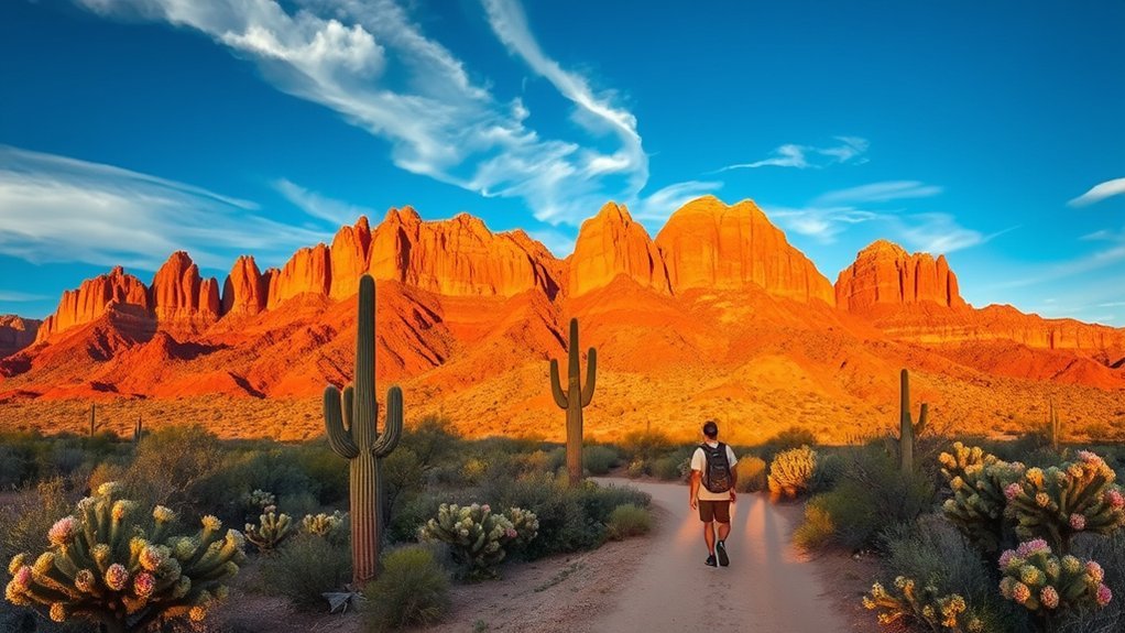
Cathedral Rock Trail, Sedona
You’ll find Cathedral Rock Trail short but steep, climbing red sandstone stairs and slickrock for dramatic views over Sedona’s vortex-filled landscape. Bring sturdy shoes, plenty of water, and use your hands on the exposed sections—there are short scrambles and uneven footing. Time your climb for cooler morning or late-afternoon light to avoid heat and catch the best views.
Trail Overview
Though short, Cathedral Rock Trail delivers a concentrated dose of Sedona’s red-rock drama and panoramic rewards, climbing steep sandstone steps and slickrock slabs to a series of saddle-like fins and viewpoints. You’ll feel the trail difficulty from the start — it’s steep and exposed, demanding steady footing and a brisk pace — but the effort buys you sweeping scenic views that strip away daily clutter. The route is direct, rocky, and often crowded; move confidently, claim a viewpoint, and breathe. Cacti, juniper, and wind-sculpted stone frame each vantage, offering moments of solitude between photo stops. Pack water, wear sturdy shoes, and respect the fragile landscape so you can leave lighter and return liberated by the red-rock silence.
Climbing Tips
After soaking in the views and steadying your breath on those sandstone steps, shift your focus to how you climb—Cathedral Rock’s short mileage hides steep, exposed moves that demand attention and deliberate footwork. You’ll move with intent: pick stable edges, test handholds, and keep low center of gravity on slabs. Prioritize gear selection—sturdy shoes with sticky rubber, a light daypack, gloves for abrasive rock, and poles stashed for approach but not for scrambling. Hydrate early, pace to manage exertion, and respect altitude adjustment; even Sedona’s elevation can sap power, so breathe deep and rest often. Choose lines that feel free rather than forced, trust your balance, and savor the ascent as liberation, not a race.
West Fork Trail, Oak Creek Canyon
Nestled in a narrow, red-rock canyon, the West Fork Trail in Oak Creek Canyon feels like a cool, emerald refuge from Arizona’s desert heat. You’ll step into a shaded corridor of cottonwoods and maples, walk along clear, ribboning water, and cross the creek multiple times on stones and logs. The trail’s switchbacks are gentle; the terrain invites steady breathing and deliberate movement. You can shed city burdens here, choosing routes that stretch from easy afternoon strolls to longer explorations upstream. Keep waterproof shoes, sun protection, and a map handy, and respect seasonal closures after storms. This trail frees you from the ordinary — a lush, accessible path where solitude and renewal meet under towering canyon walls.
Humphreys Peak Trail, Flagstaff
Summit seekers will find Humphreys Peak Trail a brisk, high-altitude challenge that rewards you with sweeping views across Arizona’s Colorado Plateau. You’ll push through fragrant pine and alpine tundra as the trail climbs to Arizona’s highest point, testing lungs and resolve. Aim for dawn to catch light that liberates the landscape and to avoid afternoon storms — Flagstaff Weather shifts fast, so check forecasts and pack layers. The route is steep and rocky; microspikes may help in shoulder seasons. Navigation is straightforward but respect elevation gain and thin air: move deliberately, breathe deeply, and summit on your terms. Descend with patience; the return is as important as the ascent for both safety and reflection.
Devil’s Bridge Trail, Sedona
You’ll approach Devil’s Bridge along a short, scenic trail that winds through classic red-rock scenery and ends at a dramatic natural sandstone arch. Keep in mind the trail can get crowded, the footing on the bridge is uneven, and exposure near the edges means you should watch kids and pets closely. Bring plenty of water, wear sturdy shoes, and time your visit for early morning or late afternoon to avoid heat and crowds.
Trail Overview
If you’re after a short, dramatic hike that delivers a true slice of Sedona’s red‑rock scenery, Devil’s Bridge Trail won’t disappoint. You’ll follow a defined path that climbs through slickrock and juniper, covering roughly 1.8 to 4.2 miles round trip depending on your chosen route. Expect packed dirt, rock steps, and some narrow ledges—trail conditions can shift with recent storms, so the surface may be slick or sandy. The payoff is the natural sandstone arch where you can stand and breathe wide open spaces. Keep your camera ready; wildlife encounters are common—lizards, ravens, and mule deer move through the canyon. It’s a freeing, concise outing that rewards movement with spectacular views.
Safety and Tips
After soaking in the arch and the sweeping views, plan ahead so your return trip stays safe and enjoyable. You’ll want sturdy hiking gear: broken-in shoes, sun protection, plenty of water, and a small first-aid kit. Start early to avoid heat and crowds, and know your limits on slick rock and narrow ledges. Practice trail etiquette—yield to uphill hikers, keep dogs leashed, and pack out all trash—so everyone can share the place freely. Stay on marked paths to protect fragile desert life and reduce erosion. If you’re seeking liberation, move intentionally: breathe, choose your pace, and leave nothing but footprints. Check weather and cell reception; tell someone your plan before you go.
Havasu Falls Trail, Havasupai Reservation
One unforgettable trek takes you deep into the Havasupai Reservation, where the Havasu Falls Trail drops into a red-rock canyon and leads to turquoise waterfalls that feel almost otherworldly. You’ll hike dusty switchbacks, descend into shade, and arrive at cascades that invite cleansing and awe. Respect Havasupai Culture: secure permits, follow tribal rules, and honor the land that gives freedom to wander. Campsites sit near rushing water; bring layers, plenty of water, and a permit confirmation. This trail frees you from routine—each plunge pool and cliff band rewires what you thought possible.
| Feature | Note |
|---|---|
| Distance | 10 miles one-way? |
| Permits | Required, limited |
| Water | Natural pools abundant |
| Culture | Tribal stewardship |
| Difficulty | Strenuous with elevation change |
Antelope Canyon (Upper), Page
Light filters through narrow sandstone ribbons in Upper Antelope Canyon, turning the walls into molten bands of orange and purple that photographers and hikers crave. You’ll move in a guided flow, surrendering to light and shadow while learning canyon geology—how water carved those sinuous walls. Bring curiosity and a desire for freedom; the slot feels like a private world.
- Arrive mid-day for shafts of light — essential photography tips for striking beams.
- Use a tripod and low ISO to capture texture and color fidelity.
- Respect guides and Navajo rules; access is controlled and sacred.
- Wear comfortable shoes; slots can be sandy and uneven.
This hike frees your vision, sharpens your eye, and connects you to ancient rock stories.
Superstition Mountains — Peralta Trail
When you climb the Peralta Trail in the Superstition Mountains, jagged ridges and rust-red boulders rise like a fortress around you, rewarding the steady uphill with wide desert panoramas and the iconic Fremont Saddle views. You’ll feel the desert open as you gain elevation; each switchback strips away noise and doubt. The Peralta Trail winds through Sonoran scrub, volcanic rock, and dramatic fins, offering both solitude and challenge. Pack water, sun protection, and a map — navigation matters where trails split. Move deliberately, breathe, and let the landscape teach you simple self-reliance. Whether you’re chasing sunrise or testing limits, the Superstition Mountains on Peralta Trail give you room to roam, rethink, and reclaim a bolder sense of freedom.
Boynton Canyon Trail, Sedona
Though the red walls and cottonwood-lined wash might slow your pace, Boynton Canyon Trail rewards you with a rare blend of towering sandstone cliffs, fragrant pinyon-juniper shade, and sweeping vista windows that frame Sedona’s layered mesas. You’ll step into a corridor of light where silence loosens your shoulders and the promise of open sky invites bold breath. The path climbs and levels, offering solitude and moments that feel like permission to shed habit.
- Hike length: ~6.1 miles out-and-back — manageable, freeing.
- Terrain: well-marked singletrack with rocky stretches — steady footing needed.
- Highlights: canyon narrows, panoramic overlooks, and rumored Sedona Vortex energy.
- Tips: bring water, sun protection, and time to sit and simply be.
Fossil Creek Trail, Strawberry
You’ll find Fossil Creek’s emerald pools and cascading waterfalls worth the trip, perfect for cooling off or photographing. Access requires a short permit process and some rough road driving, so plan your route and timing before you go. Visit in spring or early summer for highest flows, and watch for heat, flash floods, and slippery rocks to stay safe.
Waterfalls and Pools
If you follow the shaded banks of Fossil Creek from Strawberry, you’ll find a string of turquoise pools and tumbling falls that feel worlds away from the desert beyond. You’ll discover hidden gems where sunlight fractures on water and the air smells of pine and freedom. Those scenic views shift with each bend; you can rest on smooth rocks, let the current erase worries, and feel unbound.
- Wade into cool, clear pools perfect for quiet reflection.
- Stand beneath short waterfalls for a natural reset.
- Photograph moss-draped cascades against bright sky.
- Find secluded ledges to breathe and plan your next move.
Respect the place; leave nothing but footprints and renewed spirit.
Trail Access Details
When you head to Fossil Creek from Strawberry, plan ahead: the main trailhead sits at the Fossil Creek Recreation Area off Forest Road 708, where limited parking and a fee station can fill up quickly on weekends. You’ll choose freedom on clear footpaths; know the trailhead locations, arrive early, and carry permits if required. Parking availability varies—weekdays are kinder. Access roads are dirt and require cautious driving; leave no trace, take only photos, and claim space for your own peace.
| Trailhead | Distance from Strawberry | Notes |
|---|---|---|
| Fossil Creek Rec Area | 6 miles | Main access, fee |
| Strawberry Rd turnoff | 3 miles | Narrow, limited |
| Verde Rim | 12 miles | Alternate, longer |
| River Gate | 8 miles | Seasonal access |
Season and Safety
Because water levels and weather change fast in this canyon, plan your visit around the season: spring and early summer bring higher flows and wildflowers, while late summer’s monsoon storms can flash-flood trails and make crossings dangerous. You’ll seek freedom on clear days, but you’ll respect the creek’s power. Check local forecasts, trail reports, and water conditions before you go. Embrace the best seasons for safe swimming and photography, and avoid risky times.
- Pack layers and sun protection — temperatures swing quickly.
- Bring a map, charged phone, and basic first-aid; cell service is spotty.
- Watch for sudden rises in water; retreat if clouds build.
- Hike with companions, leave plans with someone, and practice Leave No Trace.
Wind Cave Trail, Sedona
Tucked among Sedona’s red-rock fins, Wind Cave Trail delivers a short but dramatic scramble to a natural alcove that frames sweeping views of the valley below. You’ll move over slick sandstone, squeeze through a narrow opening, and emerge into a wind-carved pocket where Sedona scenery unfolds like a reward. The route is brief—about 1.5 miles round-trip—but demands attention: low-profile climbing, exposed ledges, and loose rock. Pack hiking essentials: sturdy shoes, water, sun protection, and a small first-aid kit. Go light but prepared so you feel unburdened and free. Early mornings or late afternoons give softer light and fewer people. Respect fragile cryptobiotic soil, leave no trace, and savor the panorama that opens your chest and clears your mind.
Mount Lemmon — Aspen Loop, Near Tucson
Aspen groves ring the Aspen Loop on Mount Lemmon, delivering a cool, fragrant contrast to Tucson’s desert heat and an easy-to-moderate 3.5-mile circuit that showcases high-elevation pine, sweeping valley views, and seasonal wildflowers. You’ll feel liberated as you step beneath aspen trees, their trembling leaves promising quiet and renewal. The trail’s gentle climbs open to scenic views that stretch to the desert below, offering perspective and calm.
- Elevation gain: moderate—bring layers for rapid temperature shifts.
- Best season: fall for golden aspens, spring for wildflowers.
- Trail footing: well-maintained dirt with occasional roots—sturdy shoes recommended.
- Accessibility: reachable from Catalina Highway; parking fills on weekends.
Respect the forest, leave no trace, and breathe freely.
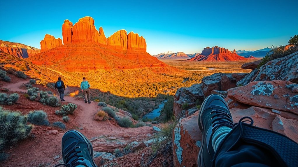
Parsons Trail (Canyon De Chelly), Chinle
You’ll follow Parsons Trail as it descends from the rim into Canyon De Chelly, passing towering sandstone walls and ancient Puebloan ruins. Expect a steady, rocky descent with narrow switchbacks and some exposed sections, so bring sturdy shoes and plenty of water. Permit rules and seasonal access can affect your route and return options, so check Navajo Nation regulations and trail conditions before you go.
Trail Overview
While you stay alert for rattlesnakes and sudden weather shifts, the Parsons Trail drops steeply from the Chinle rim into Canyon de Chelly, delivering dramatic sandstone walls, ancient cliff dwellings, and a quiet sense of scale you don’t get from the rim overlooks. You’ll feel liberated walking where history and vastness meet, choosing your pace among clear trail difficulty levels and shifting light that turns walls to gold. The descent rewards patient observers with secluded alcoves and intimate scenic viewpoints that humble and free you.
- Steep switchbacks that demand steady footing and resolve.
- Exposed canyon floor with shifting sun and cool shade.
- Close views of ancestral ruins, quiet and powerful.
- Return climb that tests grit and grants perspective.
Hike Logistics
Because the trail drops quickly from rim to floor, plan for a steep, sustained descent and an even tougher return climb—carry plenty of water (at least 2–3 liters per person), high‑energy snacks, and sun protection. You’ll want focused trail preparation: check Navajo Nation access rules, sunrise/sunset times, and heat forecasts. Start early to claim cooler hours and silence. Pack light but smart; your freedom depends on movement, not weight.
Equipment essentials include sturdy boots, trekking poles for the climb, a sun hat, SPF, and a layered wind shell. Bring a basic first‑aid kit, map/GPS, and a charged phone or satellite communicator. Leave no trace, respect local cultural sites, and hike with humility—this canyon rewards those who move deliberately and respectfully.
Waterfall Trail (Seven Falls), Sabino Canyon
Cascading water and sunlit boulders guide you up Sabino Canyon’s Waterfall Trail (Seven Falls), a steep 3.7-mile out-and-back that rewards effort with pools and a series of seven drops after winter and monsoon rains. You’ll move through slot canyons, hop granite slabs, and feel liberated by each exposed ridge. Bring water, sturdy shoes, and respect for the creek’s seasonal moods. This trail excels for waterfall photography and observing trail wildlife; dawn or late afternoon light frees compositions and encounters.
Cascading water and sunlit boulders lead up Sabino Canyon’s steep Waterfall Trail — dramatic drops, pools, and prime light for photos.
- Pace — steady climbs, frequent rests to savor views.
- Photo tips — use a polarizer, slow shutter for silky cascades.
- Wildlife etiquette — observe quietly; don’t feed animals.
- Safety — check flash flood forecasts and park hours.
Frequently Asked Questions
Are There Permits or Reservations Required for Backcountry Camping Nearby?
Yes — you’ll often need permits or reservations for backcountry camping; check backcountry regulations, secure permits where required, practice Leave No Trace camping etiquette, and you’ll freely explore with responsibility and minimal impact.
Which Trails Are Dog-Friendly and Leash Requirements?
Like a trusted guidebook, you’ll find dog friendly parks across trails, but most enforce leash regulations: keep pups leashed in preserves and popular routes, though some dispersed backcountry sections allow off-leash control—always check local rules first.
What Are Nearest Public Transit and Shuttle Options to Trailheads?
You’ll find trailhead accessibility varies: many trailheads link to public transport or shuttles, but some require rideshares or parking. Check local transit maps, park shuttle schedules, and accessibility info to plan liberated, car-free access.
Where Can I Refill Water or Find Potable Sources Along Routes?
You won’t find sirens singing potable springs; refill at trailhead kiosks, campgrounds, and some ranger stations, and purify creek water with a filter or tablets. Carry extra, follow hydration tips, and reclaim your freedom.
Are There Avalanche, Rockfall, or Seasonal Hazard Warnings to Check?
Yes — you should: check avalanche safety advisories, trail reports, and local ranger stations; use rockfall precautions like helmets and keeping distance from cliffs; carry maps, monitor weather, and respect seasonal closures for freedom and safety.
Conclusion
You came for epic vistas and ended up doing math on switchbacks — classic. You’ll hike Camelback’s sweat equity, marvel at Bright Angel’s endless rim drama, and find hush by West Fork’s creek. Pack water, shoes that won’t quit, and a sense for altitude (Flagstaff’s not kidding). Whether you’re chasing waterfalls, red-rock sunsets, or a summit selfie, Arizona’s trails deliver. Go earn the view — the state’s been waiting patiently.